 ™
™TRADITIONAL MOUNTAINEERING
™
www.TraditionalMountaineering.org
™ and also
www.AlpineMountaineering.org
™
 ™
™
FREE BASIC TO ADVANCED
ALPINE MOUNTAIN CLIMBING INSTRUCTION™
Home
| Information
| Photos
| Calendar
| News
| Seminars
| Experiences
| Questions
| Updates
| Books
| Conditions
| Links
| Search
![]()
Click on an image to see the full version; broadband folks can click here to see the full sized page.
Copyright© 2004-2012 by Robert Speik. All Rights Reserved.
The two stunning photos above, taken from his PPC, Copyright© 2006 by Q. All Rights Reserved.

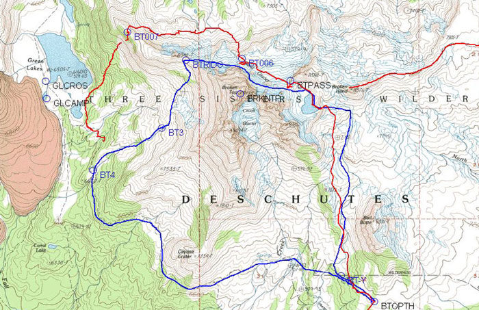
A description of our actual route in August 2004:
The blue line represents our proposed route. The
red line is part of our actual route.
We found it un-appealing to climb up to
the proposed ridge-crossing at GPS point BTRIDG as the snow pack had melted and
it was a steep loose scree and rock climb. We headed directly for a red colored
ridge that gently met the main North-West Ridge further down from the proposed
crossing point. We had a miserable trip up and down and across loose talus
moraines on the direct line. In retrospect we would have been better advised to
have read our maps and stayed low and contoured in the flats and then gone up
the easy red ridge. Just at the top of the red ridge we found serious ice under
light snow and scree. We geared up again with crampons and ice axes and we
deployed the rope to use as a fixed hand line.
When we reached the easy sandy
top of the main ridge we heard thunder and made the decision to go straight down
a steep loose dirt and rock slope to the trail among the trees along the largest Green Lake.
We had planned to go (up
the easy ridge for fifteen minutes and) down the traditional climber's trail on easier ground,
crossing the (lightening exposed) sloping sandy soil to GPS points BT3 and BT4. This was
a fortunate decision "to go straight down" as we were assaulted by a fearsome thunder, lightening,
hail and rain storm just as we hit the trees along the Green Lakes Trail and
headed for the rigs. The total distance was about 10.5 miles, the gain and loss
was 2,730 feet and the adventure took us about eight and a half
hours of work and play. Compare this description to the
Prospectus and check the
photos above.
--Bob Speik
![]()
Read more . . .
Prospectus for a Broken Top Circle Two pdf pages
A cross country circumnavigation of Broken Top in late summer
Prospectus for two day adventure with friends Two pdf pages
A cross country circumnavigation of South Sister in September
CASCADES SUMMITS
Photos of a South Sister snow-climb in June 2006
Photos of Central Oregon from an ultralight aircraft
Views of the Oregon Cascades in the summer and fall
Views of the Cascades from the ridge above Three Creek Lake
Summits of the Oregon Cascades from Tumalo Mountain in February 2005
A snowshoe summit of Vista Butte off Cascades Lakes Highway near Bend, OR
Mt. Bachelor, the Three Sisters and Broken Top
Photos of the Three Sisters Wilderness Summits form Sparks Lake
Geocaching the Top of Black Crater
Overlooking the Three Sisters from Mt. Bachelor
![]()
Three Sisters summits
![]()
Scott shares his summits of Middle Sister and Mt. Thielsen
PROFESSIONAL PHOTOGRAPHERS
Ben Moon, MoonFoto
Bruce Jackson Photography
Aerial photos of the Cascades summits by Mark and Jody Tuttle
NORTH SISTER
Timberline Mountain Guides lead North Sister climbs
North Sister, the Terrible Traverse in September, 1999
Middle and North Sister exploratory adventure
![]()
North Sister and Middle Sister spring summits on telemark skis
North Sister, Scott's solo summer summit
North Sister exploratory
North Sister winter solo
North Sister: crux photos of the Three Sisters Marathon
North Sister by the south east ridge
MIDDLE SISTER
Middle and North Sister exploratory adventure
![]()
North Sister and Middle Sister spring summits on telemark skis
Middle Sister spring summit
SOUTH SISTER
The Fall Creek Trail to Moraine and Green Lakes near Bend Oregon
Photos of a South Sister snow-climb in June 2006
A cross country circumnavigation of South Sister in September
South sister spring overnight snow climb, gear and skills
South Sister Summer Summit
South Sister climbers trail relocated
South Sister Spring South Ridge Summit
BROKEN TOP
Hiking to the glacial tarn below Broken Top in the Three Sisters Wilderness
A cross country circumnavigation of Broken Top in late summer with friends
Broken Top north side, with Z21 TV
Broken Top winter summit with Eric Hoffman
Climbing to the summit of Broken Top
Climbing Broken Top with Eric Seyler
Todd Lake, a gateway to Broken Top
Broken Top circumnavigation
Climbing Broken Top in the winter
MT BACHELOR
North American Pond Skimming Contest at Mt. Bachelor
Mt. Bachelor ski and summer resort during the Atta Boy 300
Atta Boy 300 dog sled race start and finish from Mt. Bachelor
Overlooking the Three Sisters from Mt. Bachelor
![]()
Mt. Bachelor from Tumalo Ridge
Photos of the melted snow pack near Mt Bachelor
TUMALO MOUNTAIN
Summits of the Oregon Cascades from Tumalo Mountain in February 2005
Tumalo Mountain across from Mt. Bachelor
A spring climb of Tumalo Mountain near Mt. Bachelor
MOUNT HOOD
Climbing Mount Hood in May
Mount Hood, south side route in June
Climbing Mount Hood in July
Mount Hood, Eliot glacier ice travel practice
Recent accident on Mt. Hood
MT JEFFERSON
Mt. Jefferson winter summit Eric Hoffman
THREE FINGER JACK
Climbing Three Finger Jack, a deceptively dangerous fifth class summit
Three Finger Jack
MT WASHINGTON
Geocaching the summit of Belknap Crater in the Mt. Washington Wilderness