 ™
™TRADITIONAL MOUNTAINEERING
™
www.TraditionalMountaineering.org
™ and also
www.AlpineMountaineering.org
™
 ™
™
FREE BASIC TO ADVANCED
ALPINE MOUNTAIN CLIMBING INSTRUCTION™
Home
| Information
| Photos
| Calendar
| News
| Seminars
| Experiences
| Questions
| Updates
| Books
| Conditions
| Links
| Search
![]()
PRESS RELEASE FROM
THE WHITE HOUSE
Office of the Press Secretary
For Immediate Release May 1, 2000
STATEMENT REGARDING THE UNITED STATES' DECISION TO STOP
DEGRADING GLOBAL POSITIONING SYSTEM ACCURACY
Today, I am pleased to announce that the United States will stop the intentional
degradation of the Global Positioning System (GPS) signals available to the
public beginning at midnight tonight. We call this degradation feature Selective
Availability (SA). This will mean that civilian users of GPS will be able to
pinpoint locations up to ten times more accurately than they do now. GPS is a
dual-use, satellite-based system that provides accurate location and timing data
to users worldwide. My March 1996 Presidential Decision Directive included in
the goals for GPS to: "encourage acceptance and integration of GPS into peaceful
civil, commercial and scientific applications worldwide; and to encourage
private sector investment in and use of U.S. GPS technologies and services." To
meet these goals, I committed the U.S. to discontinuing the use of SA by 2006
with an annual assessment of its continued use beginning this year.
The decision to discontinue SA is the latest measure in an on-going effort to
make GPS more responsive to civil and commercial users worldwide. Last year,
Vice President Gore announced our plans to modernize GPS by adding two new
civilian signals to enhance the civil and commercial service. This initiative is
on-track and the budget further advances modernization by incorporating some of
the new features on up to 18 additional satellites that are already awaiting
launch or are in production. We will continue to provide all of these
capabilities to worldwide users free of charge.
My decision to discontinue SA was based upon a recommendation by the Secretary
of Defense in coordination with the Departments of State, Transportation,
Commerce, the Director of Central Intelligence, and other Executive Branch
Departments and Agencies. They realized that worldwide transportation safety,
scientific, and commercial interests could best be served by discontinuation of
SA. Along with our commitment to enhance GPS for peaceful applications, my
administration is committed to preserving fully the military utility of GPS. The
decision to discontinue SA is coupled with our continuing efforts to upgrade the
military utility of our systems that use GPS, and is supported by threat
assessments which conclude that setting SA to zero at this time would have
minimal impact on national security. Additionally, we have demonstrated the
capability to selectively deny GPS signals on a regional basis when our national
security is threatened. This regional approach to denying navigation services is
consistent with the 1996 plan to discontinue the degradation of civil and
commercial GPS service globally through the SA technique.
Originally developed by the Department of Defense as a military system, GPS has
become a global utility. It benefits users around the world in many different
applications, including air, road, marine, and rail navigation,
telecommunications, emergency response, oil exploration, mining, and many more.
Civilian users will realize a dramatic improvement in GPS accuracy with the
discontinuation of SA. For example, emergency teams responding to a cry for help
can now determine what side of the highway they must respond to, thereby saving
precious minutes. This increase in accuracy will allow new GPS applications to
emerge and continue to enhance the lives of people around the world.
/s/ President William J. Clinton
New Data from U.S. National Geodetic Survey
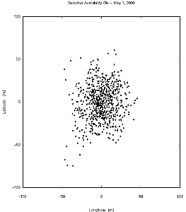
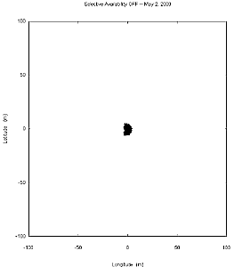
Comparison of Positions With and Without Selective Availability


May 1, 2000 May 2, 2000
The images compare the accuracy of GPS with and without selective availability (SA). Each plot shows the positional scatter of 6.5 hours of data (0730 to 1400 UTC) taken at one of the Continuously Operating Reference Stations (CORS) operated by the U.S. Coast Guard at Hartsville, Tennessee. On May 2, 2000, SA was no longer present. The plots show that SA causes 95% of the points to fall within a radius of 44.2m. Without SA, 95% of the points fall within a radius of 4.1m.
DO YOU NEED RETURN ACCURACY TO ONE FOOT?
Webmeister's Note: For most all purposes about 12
feet is good enough to find your car or camp!
However, since the amazing accuracy of the $100 hand-held GPS receiver is limited to within 4.1 meters of a position
anywhere on the globe, it is a good idea to use the coordinates to guide the user to an
identifiable landmark (a large bolder or tree) and then provide a compass
bearing and distance (FROM THE TALL ROCK, GO 15.5 FEET AT 93 DEGREES TRUE) to a specific object (a snowmobile under drifted snow, or a Geocache).
It is also good to give two bearings FROM specific landmarks. The point will be
where the two bearings cross. (Try to have the two lines cross at near 90
degrees). Adding a third bearing is OK but accuracy is impaired ;-). (This
technique used in Geocaching.com is called an "offset" geocache).
--Webmeister Speik
White House Agrees to Remove Selective Availability
GPS World
September 19, 2007
In a statement late Tuesday, the White House said that President Bush has
agreed with the U.S. Department of Defense recommendation to permanently do away
with Selective Availability, the intentional degradation of the civil GPS
signal.
Specifically, the statement said that the U.S. would no longer require that the
ability to introduce timing errors in the GPS signal reserved for civilian use
be built into future generations of GPS satellites; it specifically cited Block
III spacecraft.
The White House acknowledged that this was following on the decision in 2000 to
turn Selective Availability off. "Although the United States stopped the
intentional degradation of GPS satellite signals in May 2000, this new action
will result in the removal of SA capabilities, thereby eliminating a source of
uncertainty in GPS performance that has been of concern to civil GPS users
worldwide," the statement said.
In simple terms, GPS satellites currently issue two different sets of signals
used for determining location: one for the U.S. military and its allies, dubbed
the Precise Positioning Service, or PPS, and one for civilian use, dubbed
Standard Positioning Service, or SPS. PPS actually comprises two signals and is
encrypted, whereas SPS only uses one and is unencrypted; it was designed from
the start to be less accurate than PPS. When GPS came about, the military — the
GPS satellite fleet is maintained through the U.S. Air Force — didn't want its
own technology being used against it in a conflict, so it intended to make the
civilian signal less accurate.
Early on, however, SPS proved more accurate than was comfortable for the
military, so it introduced Selective Availability (SA). SA degraded the accuracy
of the civilian signal on a global basis by introducing intentional timing
errors into the civilian signal.
Back in 2000, the U.S. government decided to turn off SA indefinitely, which is
one of the factors in the growing adoption of GPS technology in consumer
electronics today. This latest pronouncement from Washington D.C. effectively
makes the policy change with regard to SA a permanent one.
The U.S. military says SA is no longer necessary, as it has a range of
capabilities and technology to implement regional denial of service of civilian
GPS signals when needed in the area of conflict — which is why it originally
recommended doing away with SA back in 2000. Furthermore, since the advent of
GPS, a range of technologies including supplemental satellite and ground-based
navigation systems (such as DGPS, WAAS and EGNOS) have grown up to improve the
accuracy of civilian GPS, essentially rendering SA moot.
Furthermore, the U.S. Air Force has acknowledged that a recent upgrade to the
GPS ground control system will in the future provide a new "security
architecture" for supporting troops in combat.
http://mg.gpsworld.com/gpsmg/article/articleDetail.jsp?id=458483
![]()
![]()
![]() WARNING - *DISCLAIMER!*
WARNING - *DISCLAIMER!*
Mountain climbing has inherent dangers that can, only in part, be mitigated
Read more . . .
What is the best compass?
Gps, Map and Compass
Classes
Free TraditionalMountaineering field Seminars
BACKCOUNTRY NAVIGATION
How accurate is the inexpensive hand-held GPS today?
Can you get me a $30 rebate on your favorite GPS: Garmin's Legend?
pdf form
What are some good Central Oregon Geocaches?
What is the Public Land Survey Grid?
pdf
What is the UTM Grid?
six pdf pages
Which GPS do you like?
![]()
Which Compass do you like?
![]()
How do you use your map, compass and GPS together, in a nut shell?
How can I learn to use my map, compass and GPS?
Do you have map, compass and GPS seminar notes?
six pdf pages
Map, Compass and GPS
Searching for the
perfect gift
Geocaching: What's the cache?
Geocaching into the
Canyon of the Deschutes
Can you catch the geocache?
Z21 covers Geocaching
Tour The Badlands with ONDA
The
art of not getting lost
Geocaching:
the thrill of the hunt!
GPS in the news
A GPS and other outdoor gadgets make prized gifts
Wanna play? Maps show you the way
Cooking the "navigation
noodle"
The Badlands
Geocaching in the Badlands
Geocaching Three Buttes
The Badlands, a brief history
Lost and found
What happened to the three climbers on Mt. Hood?
Two climbers become lost descending Mt. Hood
Missing California family found, dad dies from exposure and hypothermia
Missing man survives two weeks trapped in snow-covered car
Missing snowmobile riders found, Roger Rouse dies from hypothermia
Lost snowmobile riders found, one deceased from hypothermia
Longacre Expeditions teen group rescued from the snowdrifts above Todd Lake
Lost climber hikes 6.5 miles from South Sister Trail to Elk Lake
Hiking couple lost three nights in San Jacinto Wilderness find abandoned gear
Expert skier lost five days in North Cascades without Essentials, map and compass
Climber disappears on the steep snow slopes of Mount McLaughlin
Hiker lost five days in freezing weather on Mount Hood
Professor and son elude search and rescue volunteers
Found person becomes lost and eludes rescuers for five days
Teens, lost on South Sister, use cell phone with Search and Rescue
Lost man walks 27 miles to the highway from Elk Lake Oregon
Snowboarder Found After Week in Wilderness
Searchers rescue hiker at Smith Rock, find lost climbers on North Sister
Girl found in Lane County after becoming lost
on hiking trip
Search and rescue finds young girls lost from family group
Portland athlete lost on Mt. Hood
Rescues after the recent snows
Novice couple lost in the woods
Search called off for missing climber Corwin Osborn
Broken Top remains confirmed as missing climber
Ollalie Trail - OSU Trip - Lost, No Map, Inadequate Clothing
The Sport of Alpine Mountaineering
Climbing Together
Following the Leader
The Mountaineers' Rope
Basic Responsibilities
![]()
The Ten Essentials
Mission

Copyright © 1995-2007 by Robert Speik. All Rights Reserved.